BAO 28 Apr 2015
~1730-1800 UTC the T/RH was replaced at 300m. S boom was in (bad directions) and N boom may be off by 5- 15 degrees too.
NCAR reported all looks good now.
~,4" of precip with last system.
Wednesday, April 29, 2015
Tuesday, April 28, 2015
Data and quicklooks from the Halo Photonics Streamline lidar are available at
https://engineering.arm.gov/~newsom/Doppler/offsite/xpia/Halo/
This includes the "raw" radial velocity data, as well as processed VAD winds, and vertical velocity statistics (variance, skewness, kurtosis, cloud base height, cloud fraction, cloud base vertical velocity, and velocity precision estimates).
The Halo maintained a consistent scan schedule throughout its deployment period (from March 6th to April 16th). The scan schedule was as follows:
- 8 beam PPI scan at 60 deg elevation once every 12 minutes.
- narrow sector scan toward light posts near the EHS stadium once per day.
- ~10 minute slant-path stare near 50-m level on the BAO tower once per hour.
- Vertical stares the rest of the time.
Sunday, April 26, 2015
Motion Table April 24, 2015
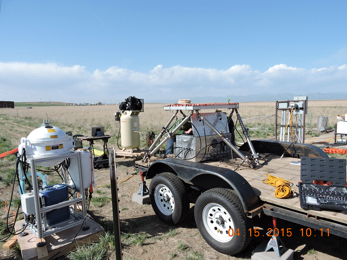
Looks very cool, especially when moving.
What you see is the motion table mounted on the trailer with the Vindicator "Egg" sitting on the platform. The trailer sits inside a wind screen/break.
 The air compressor that provides power to the motion arms is covered by the blue tarp off to the left.
Looks very cool, especially when moving.
What you see is the motion table mounted on the trailer with the Vindicator "Egg" sitting on the platform. The trailer sits inside a wind screen/break.

Friday, April 24, 2015
BAO 300m T/RH
Now the fan on this sensor has gone bad. We measure the fan current and our software removes data when the fan is not operating. We could use the data, but they would be contaminated by a radiative heating error.
Replacement being prepared by NCAR and will be replaced some time next week.
All other sensors working.
Thursday, April 23, 2015
3D Volume Scans
Over the last three days, the four 200S lidars and HRDL were engaged in testing various configurations of volume scans to measure and visualize flow behind a wind turbine. With this goal, the following two configurations were tested.
1. Small box pattern:
 This pattern has a high update rate of once every 15 sec. It envelops a small volume of 100mX100m and from 30m above ground to 130m above ground. This pattern is focused on producing retrievals just behind or ahead of a wind turbine.
2. Medium box pattern:
 This pattern covers a slightly larger volume of approx 400mX400m and from surface to 200m above the ground with ~15m vertical resolution at each of the scan intersections. Due to the larger area coverage the update rate is reduced to once every 1 min.
1. Small box pattern:
2. Medium box pattern:
Tuesday, April 21, 2015

Friday, April 17, 2015
Weather warning - hard hats recommended near the guy wires due to chance for falling ice
Posting for Dan Wolfe:
The situation at the BAO is extremely wet, slushy, and messy. Over 1.5" of precip have fallen, which is a lot of this site, so even the roads are likely to be complicated. There could be slush or possible ice on the tower and guys, so activity near the guys should include using hard hats (available in the Visitor Center and in the trailer at the tower base) in case of ice falling from the guy wires.
The situation at the BAO is extremely wet, slushy, and messy. Over 1.5" of precip have fallen, which is a lot of this site, so even the roads are likely to be complicated. There could be slush or possible ice on the tower and guys, so activity near the guys should include using hard hats (available in the Visitor Center and in the trailer at the tower base) in case of ice falling from the guy wires.
Thursday, April 16, 2015
UTD 200S: Assessment of LiDAR measurements against sonic anemometry
The UTD team is working on the intercomparison between the radial velocity measured by the UTD WindCube 200S and the 3D velocity measurements carried out with the CSAT3 sonic anemometers installed over the met-tower. In this post measurements performed in proximity of the sonic anemometer installed on the South-East boom at height of 50 m are shown. For this test the UTD 200S measured with an elevation angle of 11.49 deg, and the azimuthal angle between the laser beam and the SE boom was 98 deg. The three wind velocity components measured by the CSAT3 are retrieved in order to obtain the equivalent radial velocity seen by the UTD 200S. In Fig. 1 the comparison between the radial velocity retrieved from the sonic data and the one measured by the UTD 200S clearly shows a very good agreement between the two measurement techniques. These data were acquired from 2015-03-22 16:00:08.806244 UTC till 2015-03-22 16:14:38.285902 UTC. For this analysis no temporal correction was performed, assessing the time synchronization of the LiDAR carried out with the embedded GPS.
 |
| Fig. 1: Comparison between the 3D velocity data obtained from the CSAT3 sonic anemometer and the radial velocity measured by the UTD 200S. |
In the following some numbers to quantify the LiDAR accuracy:
Mean value for the lidar radial velocity: -3.07 m/s
Mean value for the sonic radial velocity : -2.91 m/s
Standard deviation for the lidar radial velocity: 0.32 m/s
Standard deviation for the sonic radial velocity: 0.42 m/s
The higher standard deviation of the sonic data is connected to the higher sampling rate (20 Hz for the sonic and 2 Hz for the LiDAR) and smaller sampling volume (30 cm for the sonic, 50 m for the LiDAR).
In Fig. 2 a zoom in of the comparison between the sonic and LiDAR data is reported.
 |
| Fig. 2: Comparison between the radial velocity measured by the UTD 200S and the one retrieved by the sonic anemometer CSAT3 installed on the SE boom at 50 m height. |
 |
| Fig. 3: Intercomparison between the UTD 200S measurements performed in proximity of the sonic anemometer at 50 m height and the wind data acquired by the sonic anemometers deployed at different heights. The regression analysis of the LiDAR data vs the sonic anemometer data shows a slope of 1.072 and an R-squared value of 0.6682 (Fig. 4). 
Fig. 4: Linear regression between LiDAR data and sonic anemometer data.
|
Wednesday, April 15, 2015

Tuesday, April 14, 2015
Temperature Profiles at Watertank
Last Friday a Kipp & Zonen Microwave Temperature Profiler (MTP-5) was installed at the LeftHand Water District site (a.k.a. Watertank). Below the timeseries for Saturday and Sunday (top and bottom images, respectively). This instrument is generating a temperature profile every 5 minutes with a vertical resolution of 50 m from the surface up to 1 km.


Monday, April 13, 2015
Updated tower files
A very small error in boom orientation (3 degrees) has been identified, and Gordon Maclean from NCAR has corrected the datafiles as of 13 Apr. Gordon says:
The netcdf files have been reprocessed with updated boom azimuths of 154 and 334.
The netcdf files have been reprocessed with updated boom azimuths of 154 and 334.
This includes the 5 minute files at ftp://ftp.eol.ucar.edu/pub/
and the high rate files at ftp://ftp.eol.ucar.edu/pub/
The
high rate files have also been re-formatted. They now contain 12 hours
of data instead of 4, and so for each day the files are named
cabl_ntc_YYYYMMDD_HH.nc, where HH is 00 and 12. If you've downloaded
high-rate files before, you should replace the 00 and 12 files with the
new ones and delete files with HH fields of 04,08,16 and 20.
Sunday, April 12, 2015
UTD 200s: RHIs and Virtual tower experiment
The UTD 200S and the two NOAA 200S have been performing simultaneous Range-height indicator (RHI) scans, which are performed by keeping fixed the azimuthal angle of the scanning head and sweeping the elevation angle within a certain range. The three LiDARs performed scans by intersecting the three measurements plans in correspondence of the lidar supersite location, in proximity of the SE sonic anemometers of the met-tower, and over another location where the TTU ka-band radar was also performing virtual tower measurements. Preliminary data analysis shows the characterization of wind shear and low level jet through the RHI measurements.
Fig. 1: RHI scans during the occurrence of a Low-Level Jet.
Fig. 2: Wind shear characterized through RHI scans.
Fig. 3: Wind shear characterized through RHI scans.
Thursday, April 9, 2015
Rotated radimeters for low-level scans @ 0deg elevation angle
Subscribe to:
Comments (Atom)